
|
|
|
|
Ads by Infohub
Partnership with TGCT
Mutual Support with JCA |
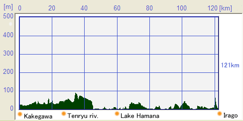
Length of Japan : TokaidoCountryside with Hamana Lake : Kakegawa city - Irago cape (121km)Map of this routeSummary
Profile map
Detailthe north shore of Lake hamana-koFrom Kakegawa(掛川) to the cape of Irago Misaki(伊良湖岬), the route is based around National Route 1, but most of this road and the Enshu Bay(遠州灘) area are heavily built-up and traffic is heavy. So, on this section, we suggest moving the Route inland away from R1/ Toukaidou, as this would provide more comfortable and safe riding. Around the Kakegawa railway station, the road is somewhat narrow and the overall road condition makes it uncomfortable for riding. At the intersection in front of the Kakegawa station you need to go west and you will then cross the bypass of the R1 which is elevated road. The JCN Route now follows Route 40 and you should turn left onto this road. The road conditions are still not comfortable and at the Y forked junction marked "Hongou West(本郷西)" you should turn onto Route 81, another narrower road. The JCN Route soon bears left and crosses a railway. The JCN Route now follows Route 81.  Route 81 goes through farmland and rice paddy fields and carries much less car traffic. When you meet T junction with route 58, make a left turn and then a right turn at the first traffic signal and across the bridge. This way does not exactly follow Route 81 but it returns to Route 81 soon. Going straight on Route 81, you should reach the pretty small railway station of Ichinomiya(遠江一宮駅). The JCN Route and R81 merge with Route 40. By taking Route 40 and keep heading west, will lead you to the Tenryu River(天竜川) which is famous for its wild water during the rainy season between June and July. Just before crossing the Tenryu river, you will meet the junction of National Route152 and National Route 362 at a place called Tenryu Futamata(天竜二俣). If you make a right turn here, the Southern Alps, which are the steepest mountains on the island, come into view. We keep going straight at this intersection along National Route 362 and across the Tenryu river. This Route is not so comfortable, however, it has mountain views on your right hand farms and fields spread away on your left. Continuing on National Route 362, you will come to Lake Hamana(浜名湖) which is famous for production of eels. If you are bored with R362, you may select an alternative route which goes south of the original route. Crossing the railway and following a winding road in the hills, you make a left turn at a Y forked junction with a wider road. Passing through downtown Kiga City(気賀市), National Route 362 reaches Lake Hamana. If you look closely at the lake shore, you will easily find a bicycle track along the lake shore and if you wish you can take this lake shore track as it will rejoin the main Route on the western side of the lake. National Route 362 separates from Route 310 just after Sunza Pass(寸座峠). From here we go along Route 310; very relaxed lake shore ride. Please enjoy Lake Hamana. Atsumi-peninsula to Irago-portAcross the Shin-Seto Bridge(新瀬戸橋), the Route meets the National Route 301. You should keep going straight and when you come to the west side of Lake shore, turn left for Route 330. This road will become Route 3. At the junction on Route 3 in front of the Futagawa railway station(二川駅), you need to turn left and go to the Futagawa station. From there turn right and then turn left when you meet the Shinkansen express-train elevated railway. Between the junction in front of the Futagawa station and the Shinkansen elevated railway, there are no traffic signposts, so you will need to remember that you must go west from the Futagawa station to the Shinkansen elevated railway. You then go under the elevated railway and should see the sign of Route 31 which is where you are headed. Route 31 is a circular road that loops around the suburbs of Toyohashi City(豊橋市). Although the volume of traffic on the road is quite high, the road is also quite wide enough. When you see the National Route259, turn left onto it. At the time of writing, National Route 259 is undergoing re-alignment construction as a bypass and so the actual route you have to take may vary construction progresses. At time of writing you can reach central Tahara City central on National Route 259. Actually there are no other choices of route other than National Route 259, though it is ideal road and traffic conditions for bike riding. In the down town center of Tahara City(田原市), there is a brick building known as the Tahara Mekun house(田原めっくんはうす) where you can find local products and tourist information. Across the bridge ahead of this building the side walks wide enough to allow bicycle riding and this is a safer route to take.  About 2km further on, there is a junction with Route 28, and you should turn left to follow this Route 28. From this point until you reach Irago Cape, in the district of Atsumi Hantou(渥美半島), there are farms which grow Kiku(菊) flower by artificial light. If you are able to take a nightime ride you should take the rare opportunity to ride by the light of illuminated green houses; very special experience. Going further along Route 28 for approx 6km, the Route meets National Route 42 which runs alongside with Enshu Nada Bay. You then take a right turn on to National Route 42 heading for Cape Irago. You will come to a fishing port which is used by many fishing boats.  National Route 42 goes along the sea shore, but unfortunately most views are interrupted by the forest or houses and it is not easy to find clear ocean views. On the other hand, the cycling road is mostly parallel to the Pacific Ocean, If you like to enjoy ocean views while riding you had better to select the cycling road.  If you get lost following the bicycle track, you can simply return to National Route 42, and there will be no problems. The photo below is the signpost which marks the entrance to the bicycle track. Both the National Route R42 and the bicycle track begin to ascend just before reaching Cape Irago, and a fantastic view of the Pacific Ocean will be spread out in front of you.  Over the top of this slope, the Cape Irago will dive into your view. Going on National Route 42, you will meet the junction with National Route 259 and this road will lead you to the port of Cape Irago. You need to turn to left at the junction and you will arrive at Cape irago. There are frequent ferry boats from Irago to Morozaki in Aichi Prefecture(愛知県師崎), Ferry boats to Toba in Mie prefecture(三重県鳥羽) are also available. In order to avoid the crowded busy metropolis of Nagoya(名古屋), you should take the ferry boat going to Toba city in Mie prefecture and from there go on to Kyoto(京都). At the Ferry Terminal, you are able to buy local food and products to collect tourist information while waiting for your ferry boat.   about ferryIt is a shame that the ferry company announced that it plans to discontinue the line between Irago and Toba at the end of September 2010. A campaign collected 119 thousand signatures for a petition to continue the line according to the news reported on May 27, 2010. Ferry is working at least from 2013 to Mar. 2014
uploaded:07, 04, 2019 |

 Time table[J]
|
|
|
Copyright "Japan Cycling Navigator". All
rights reserved.
|
